Vesta: 50S 180EW Tarpeia, Pinaria
Steven Dutch, Professor Emeritus, Natural and Applied Sciences, Universityof Wisconsin - Green Bay
Scale: 1 pixel = 600 meters. 10-degree grid; Lambert Conformal Conic Projection, Center 50S 180W
Legend
Elevation
The topographic map is a reprojection of NASA's equirectangular global map. Digital topographic data is not presently available. NASA released data briefly and then withdrew it. Hopefully it will be re-released once NASA and the IAU get done with their poo-flinging contest over coordinate systems.
Colors range from purple for low elevations and white for highest. The lowest elevation is about 22 km below the mean radius and highest is 19 km above. The transition from green to light blue marks zero (mean) elevation
Geology
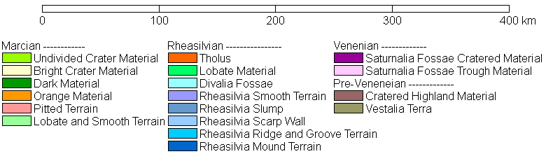
Structual features are shown as follows:
- Scarps are dark green with hachures on the downdropped side.
- Dorsa (compressional ridges) are black lines with solid black diamonds.
- Fossae and grabens are black lines with X's.
- Named craters are plain circles.
Discussion
Vesta Geology Index
Return to Global Geology Index
Return to Professor Dutch's Home Page
Created 27 January 2015, Last Update 19 January 2020